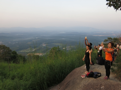
The unofficial definition of a mountain in Malaysian hiking circles is that it must be a minimum of 1000 meters tall, which would make the 400 meter Broga Hill at best of average height for a hill. Nevertheless Broga Hill’s accessibility, unique landscape and picturesque views has made it exceptional.
Attracting large crowds at the weekends, walkers, hikers, campers and even couples of various fitness and experience levels drive under the cover of the night to make the 30 minutes to one hour climb to see the sun rise. And with 3 hillocks before summiting, you needn’t even hit the peak to enjoy the views.
Starting in a palm oil plantation small holdings, the trail starts in a small woods and is narrow in places and bordered by undergrowth and ravines.
Out from under the forest canopy, the path is wider and steeper and sometimes requires the use of rope.
Of the 3 hillocks, we found the first and third the busiest, but all are flat and open and have enough space for campers to pitch their tents. In fact once you’re on this part of the trail, surrounded by grassland, it’s quite easy to find a place to stop and sit without getting in the way.
Just before the peak, after the third hillock, the trail splits into two with one path on the left heading up and the other on the right appearing to head down. Instinctively we took the former route but it proved to be the tougher of the two requiring rope work and some pushing from below and lifting from above to hoist ourselves up the rock face.
Compared to the other hilltops, the peak is dominated by huge boulders but all are climbable and hold enough room for everyone to grab a seat and wait for the natural theatre to follow.
The return journey is the same with a few exceptions which are sign posted “Exit” but the general rule on Broga Hill is keep to the left. The trail down the first hillock headed towards the forest is particularly steep so extra caution is needed.
As the hike up was done in the dark I didn’t snap any pictures, so everything you see below were taken on the way back. (Note: Since this visit, the trail has changed significantly following damage caused by clearing by JAKOA (Jabatan Kemajuan Orang Asli / Department for Orang Asli Development) and RISDA (Rubber Industry Small Holders Denvelopment Authority) for the purposes of a rubber plantation. The trailhead and routes between the 3 hillocks and peak remain the same.)
After reaching the top of Broga Hill we headed onwards to the peak of Gunung Tok Wan. By the time we returned approximately 2 1/2 hours later, we had the hills to ourselves. The hordes of hikers had melted away, tents had been packed up and the mini economy – stalls selling food and drink – that springs up at the foothills to cater to them had closed up.


Altitude A paltry 400m but you’ll be rewarded with so much for so little.
Distance and time The 1.7km to the peak should take between 30 minted to an hour.
Rating KL Hiking rates Broga Hill as easy to moderate. Although steep, it’s a short hike so if you come early enough you can take your time getting to the top.
Facilities Parking has been made available in the small palm oil holdings at the foot of the hill and costs RM2/vehicle. Toilets are available. They are new and clean and cost RM1 to use, but close after the sunrise crowds return.
Tips
1. Wear shoes with a profile. The trail is steep and you will need adequate grip to make your way up and down.
2. Check the weather forecast. Aside from the forested area at the foothill, the trail is open grassland. This is particularly dangerous in stormy weather where there is a risk of lightning strikes. Wet conditions can also make the already treacherous slopes slipper, so you might want to give this trail a miss if it rains.
Post-hike reward Nearby Chinese village of Broga in Negeri Sembilan’s Lenggeng district does a wicked pan mee and although I didn’t try it, I hear good things about it. The route is dotted with durian farms so get ready to make a pit stop when it’s in season.
GPS coordinates (parking) 2.938431, 101.901220


Hey you ;P Was googling for some info on Broga and remembered your site! So my sis n I are planning on doing this, thus continue to Tok Wan but I guess it wouldn’t be wise if its just the two of us right? The bee part is actually the scariest part 😀
If you’re lucky you won’t be the only ones going so you could tag along with a group already there. I didn’t experience any bees but as a precaution wear a hat and bring a large scarf that you can throw over your head, face and neck if necessary.